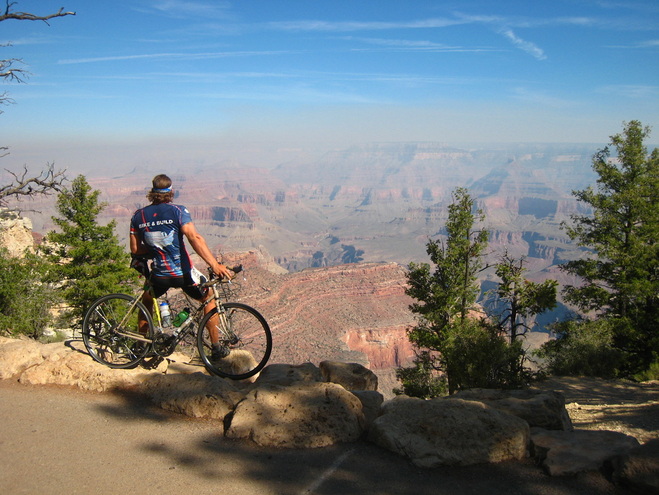
After having a much needed day of rest and relaxation in the town of Flagstaff, where several members of the group (including myself) decided they needed to live at some point in the future, we rode for just under 80 miles into the Granddaddy of all parks: the Grand Canyon.
There is a lot of build-up when approaching this great downcut in the ground; shops and trading posts with Grand Canyon souvenirs and signs start almost immediately after leaving Flagstaff. Because of all the buildup, I thought I would be able to see the canyon miles before getting there - I don't know why I thought that. After waiting in a massive line of visitors waiting to get into the park (did you know that the average time-of-stay for visitors is a mere 3 1/2 hours?), I rode for a few miles through the tall Ponderosa Pine forests of the park before catching my first glimpse of the canyon. When I saw it, however, it took my breath away. The alternating limestones and sandstones, sparkling white and red in the sun, and shale layers covered by hardy vegetation, all viewed through miles of open air, makes for one of those sights that just cannot be captured by photographs and movies.
There is a lot of build-up when approaching this great downcut in the ground; shops and trading posts with Grand Canyon souvenirs and signs start almost immediately after leaving Flagstaff. Because of all the buildup, I thought I would be able to see the canyon miles before getting there - I don't know why I thought that. After waiting in a massive line of visitors waiting to get into the park (did you know that the average time-of-stay for visitors is a mere 3 1/2 hours?), I rode for a few miles through the tall Ponderosa Pine forests of the park before catching my first glimpse of the canyon. When I saw it, however, it took my breath away. The alternating limestones and sandstones, sparkling white and red in the sun, and shale layers covered by hardy vegetation, all viewed through miles of open air, makes for one of those sights that just cannot be captured by photographs and movies.
As a short geology lesson for everyone out there, DUDE (the title of this post) refers to one of the predominant acronyms as to how the Grand Canyon was created. It stands for Deposition, Uplift, Downcut, and Erosion. Deposition refers to the process that occurred before many of these rock layers were rocks at all - they were tiny particles of dirt, mud, rock fragments, and even the shells of living creatures that sank to the bottom of the shallow sea that was formerly found where Arizona is now. Uplift refers to the tectonic processes occurring within the earth that served to force this land upwards from being a shallow sea to being 7,000 feet above sea level. Downcut refers to the process of the Colorado River cutting through these layers of rocks, exposing a 10 mile wide section of them for over 270 miles and forming one of the most amazing natural features we have on the earth today. Finally, we must remember that erosion has occurred, stripping rocks from the surface of the earth and eroding them to the sea (via the mighty river). This has erased sections of the rock record that we would otherwise be able to interpret, and this has occurred throughout the record whenever the area was exposed above sea level.
So, how exactly do we interpret the rock record? Well, we can start by interpreting the rock types. The deepest rocks that the river now runs through are metamorphic - they were warped and changed by high pressures and temperatures that were created by the formation of a mountain range in the area millions of years ago. The mountain range was then eroded away, and this is when the more recent rock record begins. These more recent rocks are sedimentary - they are formed from the deposition of all of the particles I mentioned before and turned into rocks when they were further buried by other particles. There are three main types of rocks in these layers - Shale, Sandstone, and Limestone. Now, these sedimentary rock types are formed at the same time, but in different parts of the ocean. The sandstone tends to be formed from areas where modern day beaches would exist, the shale is formed a bit further out in the ocean where more fine mud particles settle, and the limestone is formed even further out from the calcium-based shells of millions of sea organisms - primarily coral! So, the alternating layers of these rock types tells us about how deep in the ocean the area that is now the Grand Canyon was located throughout time. What does this mean? It means two things - first that sea level has risen and fallen in the past as the planet has warmed and cooled, locking more or less water up in the great glaciers. We can learn about these changes through studying this rock record. Second, that plate tectonics has played an active role in the recent uplift of this land.
So, how exactly do we interpret the rock record? Well, we can start by interpreting the rock types. The deepest rocks that the river now runs through are metamorphic - they were warped and changed by high pressures and temperatures that were created by the formation of a mountain range in the area millions of years ago. The mountain range was then eroded away, and this is when the more recent rock record begins. These more recent rocks are sedimentary - they are formed from the deposition of all of the particles I mentioned before and turned into rocks when they were further buried by other particles. There are three main types of rocks in these layers - Shale, Sandstone, and Limestone. Now, these sedimentary rock types are formed at the same time, but in different parts of the ocean. The sandstone tends to be formed from areas where modern day beaches would exist, the shale is formed a bit further out in the ocean where more fine mud particles settle, and the limestone is formed even further out from the calcium-based shells of millions of sea organisms - primarily coral! So, the alternating layers of these rock types tells us about how deep in the ocean the area that is now the Grand Canyon was located throughout time. What does this mean? It means two things - first that sea level has risen and fallen in the past as the planet has warmed and cooled, locking more or less water up in the great glaciers. We can learn about these changes through studying this rock record. Second, that plate tectonics has played an active role in the recent uplift of this land.
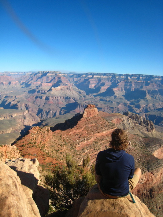
On our day off, many of us decided to casually wake up at 4 or 5 am to begin hiking before the sun's rays began to pierce the canyon air and warm it far beyond the century temperature. I opted to hike down South Kaibab Trail, hoping to explore a butte that looked interesting on the map. As we began our hike down limestone switchbacks, we saw a ranger who congratulated us on being part of the "5% Club" - only 5% of visitors that come to the Grand Canyon ever go below the rim. We continued down the trail for about 3 miles before hitting the butte, where I stopped and began to explore. I walked off the trail and around the massive knob in the landscape. On the back side of the structure, I saw a cave. I had to explore it!
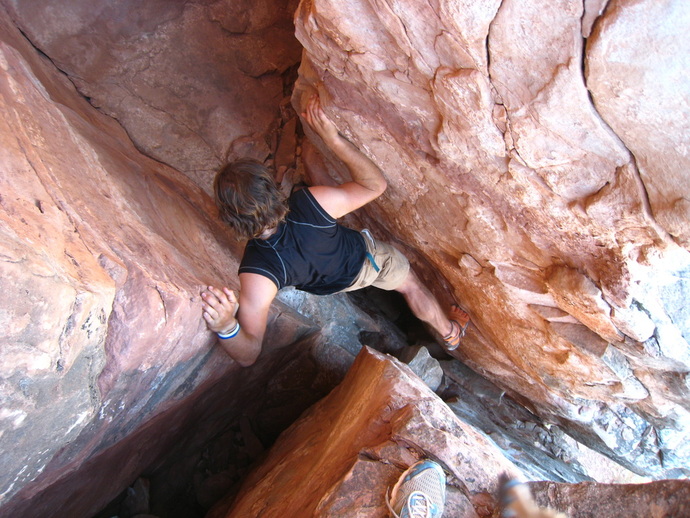
The cave went back for about 20 feet before ending. However, in the roof at the very end of the cave was a small opening that I could see light coming through from somewhere above. I reached up and was able to latch onto some over hanging rock and pull myself up, barely squeezing through the small space. Above, I found two vertical rock walls, spaced just far enough apart that I was able to shimmy up by placing one hand and one foot on each wall. After shimmying for about 20 feet, I reached a ledge that had another, perpendicularly planar crack between two vertical walls, so I shimmyed up for another 20 feet or so and reached a second ledge, almost at the top of the butte. From it, I had a view of not only the canyon, but of the steep cliffs falling from the surrounding rock straight into the muddied, brown waters of the mighty Colorado. The moment was irreplaceable.
The cave went back for about 20 feet before ending. However, in the roof at the very end of the cave was a small opening that I could see light coming through from somewhere above. I reached up and was able to latch onto some over hanging rock and pull myself up, barely squeezing through the small space. Above, I found two vertical rock walls, spaced just far enough apart that I was able to shimmy up by placing one hand and one foot on each wall. After shimmying for about 20 feet, I reached a ledge that had another, perpendicularly planar crack between two vertical walls, so I shimmyed up for another 20 feet or so and reached a second ledge, almost at the top of the butte. From it, I had a view of not only the canyon, but of the steep cliffs falling from the surrounding rock straight into the muddied, brown waters of the mighty Colorado. The moment was irreplaceable.